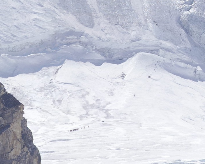
1. Of the 3 mountains, look at the peak of the center one (Lhotse).
2. Below that, the right half is big chunky snow, and the left half is smooth, icey looking snow.
3. Look at the line where the smooth left half meets the chunky right half. - Halfway up that you can find CAMP 3. [You'll see little ant people marching up that centerline - follow them to their tents.]
Also once you see CAMP 3, you actually see tracks in the snow. There's a manmade line going diagonally up/left across the center mountain, up the rock face, and then continues up/left to the little snow valley where Everest hits Lhotse along the horizon line. I suppose somewhere around there is CAMP 4.
(you can only see the people at max zoom-level, they are really tiny)
None of those little ant people are really climbing though.
Also, the resolution should have been much more than a gigapixel to make that part more interesting :)
I immediately saw the HUGE tent camp in the front though.
Thanks for the pointers, never would have found them.
There's also a big camp right at the bottom of the picture on the soil next to the glacier. There are at least two dozen tents there.
Does anyone know why? Is this photo taken early in the day so there there's no-one going for the summit yet? Or does the route to the summit go somewhere where the camera can't see?
It's absolutely driving me nuts. Makes no sense.
Nowadays it seems perfectly reasonable to imagine clicking and dragging the image around in order to pan -- I'm not confident that particular interaction would have even occurred to a lot of people a few years ago, though.
The interface is similar to RTS games, click and hold to move in that direction, not like maps.
how do they get those up and down?
Then I zoomed in some more, and realized the "trash" was actually tents.
http://sometimes-interesting.com/2011/06/29/over-200-dead-bo...
Just a reminder that those little dots are people who are taking a very real risk by attempting to reach the summit. I'm not sure if I'm envious of their drive, or if I think they are absolutely crazy.
It has gotten to the point where there are basically proven (about as much as you can for something so dangerous) methods of getting to the top.
"Into Thin Air" is a great book on the journey (the very bad , and the good) to the top.
Once I hit the "I could afford this" point I started researching Everest...read Into Thin Air, Dark Summit, No Shortcuts to the Top, etc., watched every documentary I could get my hands on, even talked with one of the climbers featured on the Discovery series that featured Russel Brice's company.
I've concluded that I'm not interested. I'm not interested in standing in line at the Second Step for hours while my body consumes itself and I burn through the scant amount of oxygen I have. I'm not interested in the very real risk that I may arrive back at Camp IV after a summit attempt to find my O2 and supplies stolen. I'm not interested in seeing the corpses, oxygen bottles, tents, and other detritus cluttering up the mountain.
I'm not condemning those who chose to go or those who help them get there, but I'm out: human behavior has made the idea of summiting Everest unappealing.
Point C3 is the last place you can actually see humans (& tents), C4 is already more of a guess.
Simple hot linking restrictions.
http://www.abc-of-mountaineering.com/images/content-images/a...
Then lost them. Amazing photo!
Found them... Spoiler: http://imgur.com/zpyOg
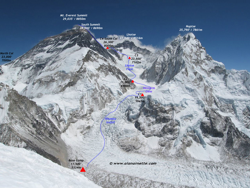
The ice field just above Base Camp (which, wow, look at all those tents) is the Khumbu Icefall, which climbers must scale to en route to the South Col.
Bit morbid though.
Did anyone find climbers lower in the icefall?
Difficult to believe how big Base Camp is!
http://en.wikipedia.org/wiki/David_Breashears
The result of a project by David Breashears, who has already climbed the highest mountain in the world five times. He used old images of Everest and its glaciers and combined them with new ones.
The photo is part of a broader project called GlacierWorks by the mountaineer Breashears, who made the much-acclaimed IMAX documentary “Everest.”
http://www.greatoutdoors.com/everest-2010/routes-maps
Look for camp 3. You have to zoom all the way in, and look at where the rough snow meets the smooth snow. You'll see some super tiny yellow dots, those are the tents. The tiny black specks just to the left are climbers.
The sense of scale in the Himalayas is almost unfathomable.....
The preview video looks promising: http://www.youtube.com/watch?v=mEs3euTgj8s
Background info: http://urcventures.com/whats-new/
I've tried to use my network inspector to figure out how to access the individual tiles, but no luck.