Yes, it’s sort of convenient at a rational level, but everything appears the same, and there’s no way to differentiate one cross from the next. Streets doesn’t have their own “personality” and you have to learn them by name. I don’t know half of the street names of the city I grew in, but I know where I am by the way they intersect and twist around in interesting shapes…
Or perhaps is just the way I’m used to
In the US, if you're on 89th Street and 5th Avenue, and you want to visit your friend on 10th and 1st Avenue, you'll know exactly which direction to drive. Need to go to another city? Take the highway following the direction the other city is. Americans are typically good at knowing where the sun rises, or are always getting lost.
In Europe, you know your friend lives by the main hospital, so you follow the signs indicating the hospital, and then (if you're lucky) signs to your friend's neighborhood. From there you need to know how to get to the street they live on. Need to get to another city? Follow the highway signs indicating that city, if it's close by, otherwise you'll need to know what cities are on the way to it.
When we lived in the US, I could easily find any address in most cities. My wife was always getting lost, sometimes going to the complete other side of town.
We've been in Europe for over a decade now. She has no problems getting around to most places she needs to. I'm always getting lost going someplace new.
Taxi drivers don't use road signs anymore for figuring out which direction to take.
I've lived in both types of cities, and actually even the most grid cities like Salt Lake City, have parts that are named as opposed to just numbered.
I prefer the numbered cities for finding way around.
Finally I don't think the everything appears the same is integral to it being a grid city, that is instead a side effect of American habits of rebuilding often so you end up with everything relatively new and in the same styles. That is to say the stylistic affect is orthogonal to the grid, although they are both found to coexist this is just a historical coincidence.
>I don’t know half of the street names of the city I grew in, but I know where I am by the way they intersect and twist around in interesting shapes…
I don't know where your city is, but I did notice many years before everyone had a phone I was in a class in Copenhagen and everyone in the class had lived in Copenhagen their whole life and then someone talked about an address and nobody knew where it was so someone had to go out to their car and get a book of maps.
Of course Copenhagen was also built to be potentially confusing to invaders, as I understand it, and I have often thought I was walking towards a particular destination to find I have either been walking away from it or perpendicular to it.
I also find that I prefer websites that are easy to navigate than ones that have character but are confusing. But I do prefer art that is apt to be confusing and intellectually stimulating to things that are simple and clear cut.
I think perhaps the problem is I just don't want going shopping in an unfamiliar part of town to feel like a surrealistic event.
Could it be that you learned the chaotic city better because you were more likely to go around on foot and experience little things, rather than just driving to a box store?
While there are advantages to grid layouts, I find they also bring a certain amount of monotony. The irregular historic street layouts of European (and some US) cities give so much more variety & make the city much more interesting.
[1] https://maps.nls.uk/view/245956114#zoom=6.5&lat=3256&lon=625...
https://www.openstreetmap.org/way/8431660 Happens to be near "wood lane". Make of that what you will.
I studied on "Silk Street" which is nearby. Nearby are also "Oat Street", "Bread Street", "Milk street", "Gutter lane", "Goldsmith street", "Poultry" and many more who have old names relating to their function.
I like those but IME most people have no clue what old names mean, they are just sounds associated with a place most of the time.
Doesn't one of CS Lewis's books have Merlin transported to modern London and he heads off down the Roman roads?
Grid layouts do have efficiency, but humans aren't built to be efficient - at least not all the time.
The problem is suburbs and modern "inefficient" roads are designed to be inefficient - not designed by and for life.
Persistence over time wouldn't make any difference to that case; Merlin is omniscient.
(Interestingly, Avenue Q was renamed Quentin Road to avoid confusion with Avenue O.)
Either way, lettered or named in alphabetical order, I appreciate the lettered/numbered combination. It's a good mix of character and practicality, and it sounds good when you say it out loud ("It's at E 14th and K"). The doubly numbered intersections of Queens always drive me nuts.
A final sidenote: some real estate developers in the early 20th century decided to rename sections of E 11th through 16th from Prospect Park South down through West Midwood to fancy-sounding anglicized names like Stratford, Westminster, Argyle, Rugby, and Marlborough (the SWARM backronym here is useful) so they could make more money selling homes on those streets. It worked. Yet another example of nefarious street naming...
Lower Manhattan also still has a large non-numbered area so you can get the old charm when you want it.
1st through 27th Avenues - they’re over 100 years old now funnily enough
So if you are at 200s in one street and are looking for a house at 1200s, you know you are a kilometer away.
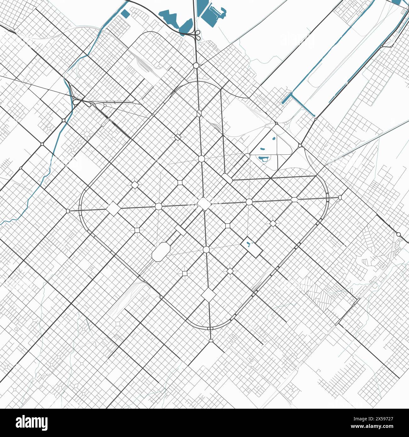
This with numbered streets is awesome to navigate. Buenos Aires has the first, but named streets. La Plata in Argentina has both.
If you are into maps see an air pic of La Plata.
https://c8.alamy.com/comp/2X59727/detailed-map-of-la-plata-c...
Then I moved back to Europe and realized it was a lie. It was just that the grid systems of the places I lived in the US were much easier to navigate.
I’m in a suburb of Charleston, SC and it’s so weird how I have no idea how far things are….1 mile? 3 miles? I miss riding my bike on that Portland grid and following the numbers all the way to zero and hitting the Willamette.
In Melbourne the North-South street go: King, William, Queen, Elizabeth, Swanston, Russell. It communicates the commonwealth history and founding history of the city. Cute, but decidedly less useful and memorable than number avenues.
Yes, Google maps can do the job, but often times just walking around feels odd.
I find named streets with odds and evens on each end much, much easier to navigate.
Also I want to add that my country uses a system where new pieces of town going beyond the original city plan and house numbering use zero as a leading number for houses going the other way, which is kind of endearing. That way you can have 20 and 020, which leads you to know which way you should be looking for.
People name streets (and other things) for other reasons too, often for internal or local reference. This perspective reduces the meaning of naming to a single focus, like saying we name dogs only to allow our guests to refer to them as needed when visiting our homes. We name things for many reasons, and those reasons are more about endearment and culture building at the local level. I recommend Seeing Like a State by James Scott for more discussion, including about street names, exploring this perspective.
Where I live now the streets are 'wavy' and have very long names, usually a person or an auspicious date - and often multiple instances quite nearby. Almost useless for navigation.
I also miss the grid system - traffic naturally gets calmed down, and you are never too far from a cross walk.
Going back to "Army" would be silly, especially since the U.S. Army never had a presence on that side of town. It was all Navy near the bay. The Army was up at the Presidio.
SF has this silly thing of giving streets secondary names. Who knows where "Herb Cain Way" or "Isadora Duncan Lane" is?
Numbered streets have their own problems. In San Francisco, 4th St. and 16th St intersect near the UCSF hospital complex.
Some distant suburbs (Du Page County and beyond) use a numbering scheme of xxWyyy where the xx is the number of miles west of State Street (the 0 in the cartesian grid of Chicago) and the yyy is the location within that mile. I don’t think they do anything similar for North-South coordinates though.
The diagonal streets in Chicago largely follow the routes of early non-grid roads of the city (many of which were plank roads run as toll-collecting businesses and followed paths used by the native American tribes living in the area before European settlement.
⸻
1. Hunnerts (from hundreds) being Chicago-speak for the location on a grid. E.g., Chicago Avenue is 800 (eight hunnert) north and Western is 2400 (24 hunnert) west.
2. This is a consequence of history. All the missing numbers (Roosevelt at 12 hunnert south is the first mile, Cermak/22nd street at 22 hunnert south is the second and 31st street at 31 hunnert south the third) do exist,³ but the streets were named and numbered before the replatting established the modern hunnert system.
3. There might not be some of the hunnerts in that first mile—the numbered streets only start after Roosevelt.
4. Not to be confused with Los Angeles’s K-town where the K stands for Korea.