We go into all the details at https://alltheviews.world
And there's an interactive map with over 1 billion longest lines, covering the whole world at https://map.alltheviews.world Just click on any point and it'll load its longest line of sight.
Some of you may remember Tom's post[1] from a few months ago about how to efficiently pack visibility tiles for computing the entire planet. Well now it's done. The compute run itself took 100s of AMD Turin cores, 100s of GBs of RAM, a few TBs of disk and 2 days of constant runtime on multiple machines.
If you are interested in the technical details, Ryan and I have written extensively about the algorithm and pipeline that got us here:
* Tom's blog post: https://tombh.co.uk/longest-line-of-sight
* Ryan's technical breakdown: https://ryan.berge.rs/posts/total-viewshed-algorithm
This was a labor of love and we hope it inspires you both technically and naturally, to get you out seeing some of these vast views for yourselves!
But... I want to see a photo! Or at least what it looks like in Google Earth, with a red arrow marking the furthest point.
It feels like the site is setting you up for the big suspense of the longest line of sight... and then it's just a line on a 2D map.
I think it would also really help if the maps themselves were at an angle in 3D with an exaggerated relief, with the line drawn in 3D, so you can get a sense of how it travels between two peaks.
It seems like you've put a ton of effort into this project. I think with just a tiny bit more work on the page, you could really put the "cherry on top".
And with those visualizations, get it picked up by a lot of major news outlets. This is a really fun story, the kind of stuff newspapers and magazines love to run. It's easily understandable, it's a cool new "record", it's a story of someone's perseverance paying off, and then you show a Google Earth image simulating the view as the payoff. (And from slightly above, if necessary, to take account for refraction.)
EDIT: Here, I used Google Earth to show the two points. Unfortunately it's from high above, since otherwise Earth wouldn't show the pin for Pik Dankova, but it at least gives a general idea of the area:
https://imgur.com/hindu-kush-to-pik-dankova-530km-adbVFwb
And here is the Google Earth link for the view, but it doesn't contain the pins:
https://earth.google.com/web/search/41.0181,77.6708/@36.6644...
Note that technically my link is a slightly longer sightline (longer by 7 km).
It even points me to google earth website with the same view: https://earth.google.com/web/@41.059167,77.684167,5853a,0d,3...
Google chrome is probably necessary for openning the site.
Also, there is a local sky island completely nontechnical wanna-be 12. Sight lines from up there are huge--except the two times I've been up there I couldn't see anywhere near as far as the supposed sight lines. Roughly 100 miles before all I saw was a haze. (And in a related thread some time ago one of these sight line plotters was getting it seriously wrong. It failed to show areas I knew I could see, it showed areas I knew were blocked by mountains.)
And like I said, the reason I didn't do it here was because it hid the label on the horizon. But here it is:
https://earth.google.com/web/@36.43138439,78.74038717,4785.2...
But without the label you can't really tell what you're looking at. And the big problem is there's no "sideways" zoom like a telescope. Google Earth effectively treats zoom like altitude only.
In my experience while hiking tall things, the Google Earth view is accurate in terms of what you see, if you manage to get the viewpoint next to the ground like this. And you appreciate that the resolution is obviously limited.
That imgur link is great, I totally see what you mean. So surely there is a way to at least automate linking to these views? I don't know about embedding them cos Google will want money. We're very open to suggestions, and PRs of course! https://github.com/AllTheLines/viewview
Chimborazo's antipode is Sumatra. That may be the best, unless there is peak in Indonesia that lines up with Andes in Columbia.
Long lines of sight are between stuff at high altitudes because at near sea level the horizon becomes a problem after only a few miles/kilometres.
Well the record for the longest photographed line of sight is in the same region as our #3 longest line, at 483km https://www.guinnessworldrecords.com/world-records/66661-lon... So not far off. And I think that even takes advantage of some favourable refraction. So not only might it be possible to see the longest view. But there may even be longer lines if we were to take into account extreme cases of refraction. Which is certainly something we'd love to try.
> He monitored weather conditions closely to find the right window and right location. After a lot of travelling he arrived at Aksu village. The village wasn't accessible by car due to snow and ice so he hiked to the summit. After 10 hours of climbing, he stood on the summit with moonlight providing enough light to set up his equipment. At midnight, he recalls that the temperature was around -12°C with winds around 8 m/s. He remained there all night capturing panoramic photos. Before sunrise, the wind picked up to roughly 20-25 m/s and the battle of capturing his world record image began. He planned to capture the image at sunrise to improve contrast and whilst he is pleased with the final result, he is already making plans for his next record-breaking image.
But still, that kinda confirms my observation about the pesky atmosphere: even with optimal weather conditions, he still needed the sun lighting up the sky behind the mountains just before sunrise, otherwise they would have blended in with the sky at the horizon...
This also applies for much shorter distances: despite what the publicity photos suggest, you can't see the Alps from Munich most of the time (or only as slightly darker shapes on the horizon), although they're "only" ~ 75 km away. You need really good weather to see them clearly...
You won't usually see them from the ground of course but from a couple floors up with a clear line of sight you do see them quite often.
Or is this just an elaborate silhouette?
Is that a difference? I don't know.
Dedication, mmm, dedication. Dedication, that’s what you need. If you want to be the best, and if you want to beat the rest. Dedication way you need.
Hopefully that means something to Brits of a certain age ;-)
[1] https://uchile.cl/noticias/205455/astrofotografo-logra-nuevo... [2] https://dalekiewidoki.pl/2025/07/world-record-andes.html [3] https://api.flickr.com/photos/robertoantezana/4994301227/
But the longest possible view isn't to the horizon, it is to another point that can see the same spot of horizon on a reciprocal bearing. And ocean has no such points.
Edit: to be clear the difference stems from our coordinates. Our starting points are:
41.059167,77.683333 (me)
41.0181,77.6708 (you)
And our end points are:
36.295364,78.755593 (me)
36.314,78.7654 (you)
Also I calculate the distance assuming the Earth is spherical (which gives 538 km) not the standard geodesic (which would give 537 km).
And in the DEM data I measure the distance from the center of a cell to another (not the edge), while measuring from edge to edge may explain a difference of at most 0.1 km as the DEM resolution is 3 arcseconds.
So clearly we disagree on the coordinates of the exact actual sightline as we have a 7 km difference :-)
Edit #2: clearly the error is on your side. I should have checked this first, but the coordinates you give for the "To" point (41.0181,77.6708) land in a valley with the south view completely blocked so it's impossible to view 500+ km south as you claim. Look at where the marker lands on this Google Maps Terrain: https://maps.app.goo.gl/PgBWxi31WZC6vk3V9
There's two forms of interpolation going on here that I'm not sure you or Dr Dueschle are using. We interpolate a "band of sight" of single a degree for our azithmual projection, but uniquely we also rotate the DEM elevations around all the observers rather than the observer around to see all the elevations.
The effects of the first can be lessened by lowering the band of sight such that we only process half a degree at a time so that we make sure we get more coverage further away. We plan on running some more experiments by rotating to cover more points.
The algorithm is already fairly expensive to run against the whole world so we weren't particularly interested in that level of coverage for the full earth.
For total viewshed area, our algorithm comes in at roughly a percent or so difference which was what we used as our benchmark for correctness.
All this to say, no, we don't think you both are wrong, we've been looking at making ours more accurate. At a world scale that's quite computationally expensive, so we didn't use that methodology for our initial launch. We see our results as validation of yours, not as something we've disproved.
Edit: grammar
The error I've experienced hunting bugs tends to be within about .5-2%. That's a vibe, not an empirical "I've calculated the error to be 1.5%". We definitely expect that bound to tighten as we get access to more computational resources.
I do not think this is numerical however. I think it's more directly related to rasterization, interpolation, and not enough angle coverage. We have fairly good numerical and viewshed tests to double check we don't have weirdness going on there.
I'm afraid I don't have a good answer. I'm sure with future runs will get closer to you and udeuschle.de
I thought of you when we saw Colombia appear so high up in the list, I remembered that's something you'd found too.
So in mine you can click on a spot and it draws black lines over any land that is occluded by terrain, within 100km.
(But all with AI-generated JavaScript, not cool Rust and SIMD stuff)
This is what I get when I set the observer height to 20m, and increase the "max distance" to 300km (200km = ~124 miles so may not be enough).
https://img.incoherency.co.uk/6478
It's also possible that the half dome is too short and the sampling rate of the line-of-sight jumps over it!
Heh, I almost hit back at the "in Rust" mention.
Would the end result have been different if it were done in python calling C libraries for performance? I strongly doubt it.
Why allow the user to select any arbitrary location on a map and give an answer when you know the answer is most likely nonsense? You don't need to compute for 2 days to accomplish that; you could just make it up.
That it's not taking into account human construction or distances of tens of meters?
Presumably you can walk a little bit and climb on someone's roof to see the claimed 24.7 km. Assuming a sufficiently clear atmosphere, and that there isn't a tall office building in the way or something.
I did some longshots back in the early days of wifi.
You could probably talk between ends using cheap crappy 446MHz 250mW walkie-talkies though.
But then the actual message would be encoded by very slightly favouring the high or low end of the spread spectrum map as a kind of terribly slow FSK.
https://www.heywhatsthat.com/ is another bookmark that I had lost to time.
Actually, I was thinking of https://caltopo.com/map.html but your site led me to it.
One advantage in NZ is that on a nice day you actually have a good chance of seeing it.
Oh ... clicking on Mt Owen doesn't return the favour ... or the other nearest peaks. But Culliford Hill does show a return back to Ruapehu, 355.4 km. Clicking on Tapuae-o-Uenuku also, as expected, gives a line to Ruapehu: 342.3km.
Mt Cook is high, but has too many other high peaks near it.
Mt Taranaki is isolated, but doesn't turn up any very long distances.
I don't expect any other candidates in NZ.
Update: actual and accidental photo of Tapuae-o-Uenuku from Ruapehu (342 km), seven months ago.
https://www.reddit.com/r/newzealand/comments/1m9p0bh/tapuaeo...
And, as pointed out in a comment, also Mount Alarm 2.5 km further.
What is the longest in North America? Or Europe proper -- not Elbrus (which I've not been to but have been close enough to see, from several places e.g. from a house in Lermontov (~94 km only), summit of Beshtau (93 km), Dombai ski field (~63 km), somewhere on A157 (~50km).
So using that, I would say that the longest line of sight in North America is from Mount Rainier, at 390km, looking North West into Canada: https://map.alltheviews.world/longest/-121.76853942871094_46...
That gives a longest in NZ of 365.3 km from Ruapehu, skirting past close by Tapuae-o-Uenuku (in the Inland Kaikoura Range) to a point on the Seaward Kaikoura Range near the peak of Manakau. Clicking on the actual Manakau peak also gives 365.3 km back to Ruapehu.
I can't seem to find a peak to get a reverse path back to Mt Ranier. Everything I try gets stuck in the Olympic Peninsular. (I was there once ... 1998 or so ... a place called Hurricane Ridge IIRC)
Anyone with expertise want to comment?
Mountains can rise higher near equator because you have the least gravity there. The whole Earth bulges along the equator. But I don't think it's measurable.
Definitions:
* Hams: Amateur radio operators.
* QSO: conversation or contact between two radio stations.
* QRP: Low power, typically under 5 watts.
https://www.k0nr.com/wordpress/2021/08/using-1-2-ghz-in-the-...
Additionally, the GPS coordinates might need adjustment, as there are several prominent peaks near both Liborina and Pico Cristóbal Colón (the summit of the Sierra Nevada mountains).
[1] https://earth.google.com/web/search/6%2e75514,-75%2e7222/@6....
[2] https://earth.google.com/web/search/10%2e8467,-73%2e7029/@10...
So you're saying a better title for the Colombian line of sight could be "Pico Lagos del Congo to Pico Cristóbal Colón"? We can definitely change that.
Thought I'm not sure what you mean about the coordinates being wrong? Are you saying that you should be able to see further from Pico Lagos del Congo?
First point: - Mountain: Cerro Lago del Congo (The GPS coords refer to the peak) - Locality: Liborina - State: Antioquia
Second point: - Mountain: Sierra Nevada de Santa Marta (The GPS coords refer to the peak, called Pico Cristóbal Colón) - Locality: Santa Marta - State: Magdalena
Pd. Hope you enjoyed your visit! I think Colombia is beautiful (But hey! I am biased)
There seems to be some missing data here when it comes to the north face of most Himalayan peaks (for example: Annapurna).
I am willing to believe looking south gives you the longer view, but there has to be some points on the north faces that win out for a northern view.
Fun fact, the view north is so far, clear and reliable weather-wise that the CIA partnered with mountaineers to set up equipment to monitor China's progress with nuclear weapons several decades ago.
https://map.alltheviews.world/longest/88.14788327735505_27.7...
https://map.alltheviews.world/longest/88.14711648199943_27.7...
If were to use absolute global values for the heatmap, then the Himalayas would just appear as pure, washed-out white.
Does that make sense?
1) Poking around our local peaks I find that the calculation appears granular, it's offering me things I could see from the summit that I could not see from where I clicked.
2) It's offering me one I never even considered looking at (peeking just beside another mountain, the terrain appeared flat, I never realized there was a distant peak there) and one I knew about--and know I have no hope of actually seeing.
And the second part was simply noting that just because there is a theoretical line of sight doesn't mean you can actually see. The southern view I know goes to haze long before what it's showing me, the northern view is such I didn't even realize there were mountains there beyond the big one close by.
if we put mt. everest on a sperical cow, i mean on a planet with only ocean, how far could you see there? how far away could a second peak of the same height be, before it gets hidden by the curvature of the planet?
And it could even be tweaked slightly with some favourable refraction.
Sorry to be pedantic, your longest view is not from the Hindu Kush, but from the mountains to the south of the Tarim Basin which are the Kunlun mountains.
The Hindu Kush are largely in Afghanistan, but also Pakistan, running in an arc from Kabul to the north east. They aren't in China.
The Hindu Kush range then gives way to the Karakoram, as you cross Kashmir, which is then bordered to the north by the Kunlun which form the arc of the southern Tarim Basin.
I suspect you're just mixing it up with the Hindu Tagh pass, just to the south of the peak your point is looking from. Hindu Tagh seems to be about as good a name as the line-of-sight community has come up with for that peak.
I think I came up with that name from a game of telephone of sources claiming to have the longest line of sight. There's a lot of really random sources on the Internet that mention the line of sight but do not cite the data or analysis. I have seen Hindu Tagh thrown around as well so if it's more accurate we want it there.
Part of our motivations were to stop the game of telephone and become an authoritative source on this stuff.
I'm not much of a geographer, more of a HPC guy.
I have this on the TODO list to update tomorrow.
[1] https://beyondrange.wordpress.com/2016/08/03/pic-de-finestre...
Well there is a photo near our #3 longest line of sight https://www.guinnessworldrecords.com/world-records/66661-lon...
Any chance of writing a QGIS plugin with the algorithm?
If you know anything about QGIS plugins please feel free to make a brief write up in our issues https://github.com/AllTheLines/viewview/issues
I might create an issue after I conceptualize what it might look like more!
I wonder how atmospheric refraction is handled in the calculations for the longest line of sight. Since it (a) strongly affects the line of sight, and (b) depends on temperature and weather, how is a static "world record" possible, or even defined? E.g. objects may appear 400m higher in 200km distance under typical conditions.
We actually have a plan to aggregate world runs together, so that one run as low refraction and a short observer, then another run with high refraction and tall observer. Then instead of rendering longest lines of sight as those singl triangles, we could render them as 2 triangles that represents the extremes of expected visibility.
Airy beams curve
This type of amplification preserves the curvature of Airy beams FWIU:
"Low-power integrated optical amplification through second-harmonic resonance" (2026) https://news.ycombinator.com/item?id=46824978
What kinds of sensing would be possible given a round-the-world photon trajectory?
Quasiparticles have mass, and so might be easier to send around the world than purportedly massless photons.
SQR Superfluid Quantum Relativity with a dilatant fluid says that the effects of mass energy equivalence at high velocities approaching c are actually due to the (atmospheric to superfluiic) viscosity of spacetime nonlinearly pushing back.
But does that matter for a photon or a massless quasi-particle like a photon that we're trying to curve initially to send around the earth at least once to win teh line of sight distance ranking?
If so, then the pyramids (and other ancient megalithic structures with quartz at 72 degree intervals) and Angkor Wat and Longyou caves and Osireon may have been the longest (non-) line of sight communication system back then in ancient times: https://gemini.google.com/share/101970a04402
Observation of a salt-formed Hydrogen-tuned NV-center diamond might resolve some of these claims?
Regular viewshed algorithms really aren't built for it, and being able to do it cheaply while also maintaining a cluster of compute that can shut down at any time is also its own mess (these were all spot instance so we could get 75+% off).
The 530km number takes into account both the curvature, along with refraction. It's a simple elevation adjustment when you are doing your angle of elevation calculations.
If you want a synopsis of how we calculate lines of sight and all the parameters we use I have a shorter, less whitepaper-y blog post here:
https://map.alltheviews.world/longest/-83.1653564346176_29.8...
Ultimately we plan to mix in higher resolution data from different more recent surveys.
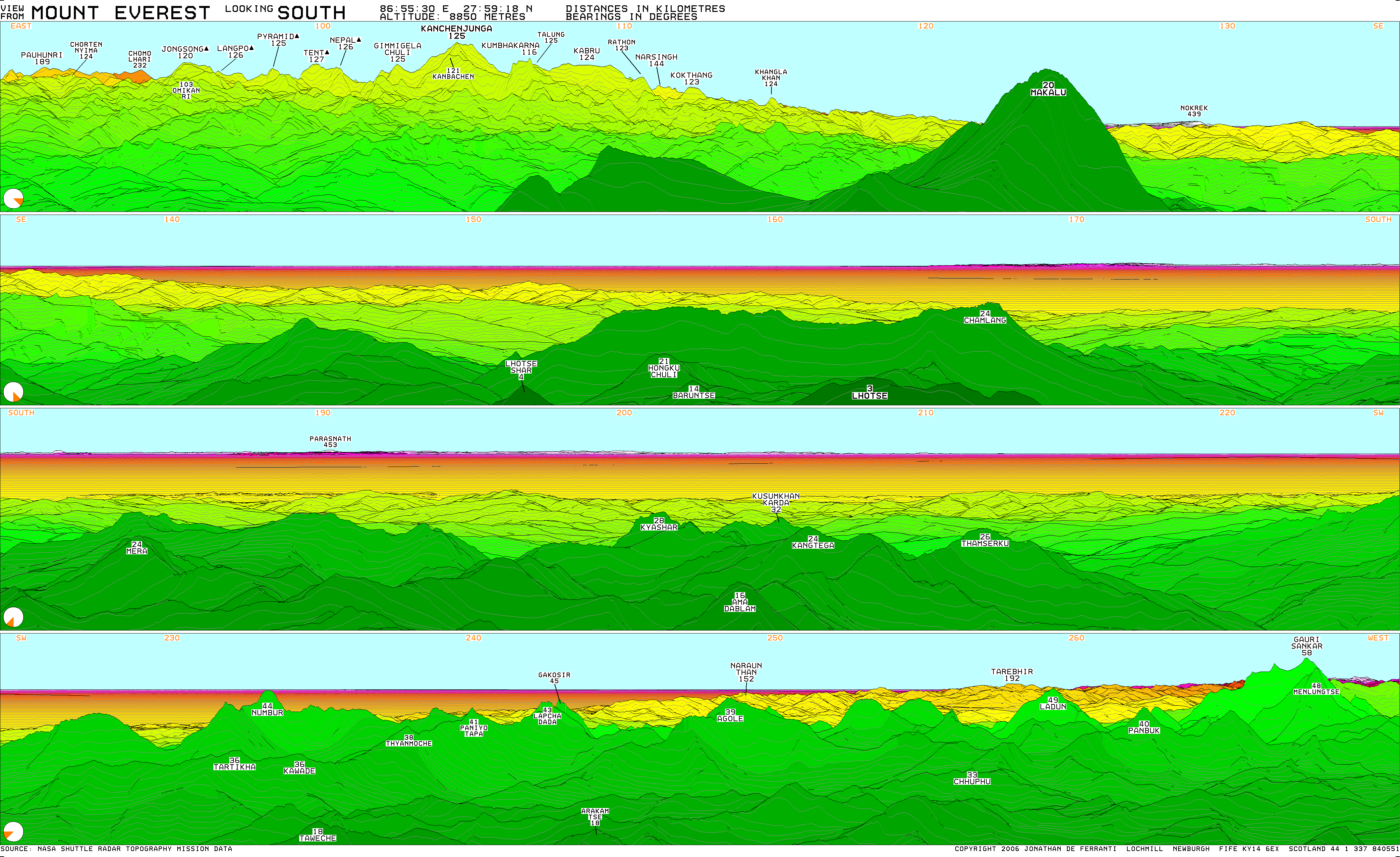
https://viewfinderpanoramas.org/panoramas/ASIA/EVEREST-SOUTH...
Thanks for this tool!
https://www.reddit.com/r/newzealand/comments/1m9p0bh/tapuaeo...
In theory there should be a 365.3 km one just barely to the left of the obvious twin peaks, but I'm not seeing it.
Quite a bit short of the longest in the world, but still pretty far to see.
Next curious fact -- the two towers of the Golden Gate Bridge are perfectly vertical, but the top of one tower is 4.6 cm (1.8 inches) farther away from the other, compared to the bottom of the towers -- because there is a small angular tilt between the towers. Guess why ...
Okay, it's because the towers are independently vertical with respect the center of the earth, are horizontally separated by 4,200 feet, and each tower is 746 feet tall. These dimensions assure that the towers have a distinct angle with respect to each other. It's a small difference, but it's not zero.
I thought about these things (and many others) during my four-year solo around-the-world sail (https://arachnoid.com/sailbook/).
This is an independent observation from the Fabra Observatory: https://english.elpais.com/elpais/2015/03/03/inenglish/14253...
https://beyondrange.wordpress.com/2016/08/03/pic-de-finestre...
I wonder if air quality/humidity permit actually seeing this far though… That’s a lot more “air” than looking up toward space…
Cheers
www.climbs.cc
500km? Whee...
I believe I _might_ have a 33km view FROM MY ROOF, from 2m above ground I have much less than 1 km.
This is cool tho. What about to an ocean point from a mountain? Was there anything longer?