Source code and additional information is available on GitHub: https://github.com/dnlzro/horizon
Well, the higher ups of course hated it, they were confused as to why the horizon would get hazy, yellowish, and so on. "Our competitors' skies are blue!" They didn't like "Use your eyes and look outside" as an answer.
Eventually, I was told to scrap it and just draw a blue rectangle :(
All that to say, nice job on the site!
1: https://courses.cs.duke.edu/cps124/fall01/resources/p91-pree...
The reality is that we have certain conventions that are immediately understandable, and that too much visual complexity results in confusion rather than clarity.
If the sky is hazy white when I expect it to be blue, I'm confused as to whether it's the sky or if the map is still loading. It's adding cognitive complexity for no reason. Stars similarly serve no functional purpose at night.
What you built sounds great for an actual planetary view like Google Earth. And it sounds fun to build. But it's an anti-feature for a navigation view. When you're navigating, simplicity and clarity are paramount. Not realism.
Also the phrase "know your audience". No sense in casting pearls before the swine.
I can understand people removing polish things like that if there are usability concerns, but those small things add up to a lot in an end product and are a joy to find and explore.
https://duckduckgo.com/?t=ffab&q=neil+degrasse+tyson+gives+j...
This is like if you were renovating your house and the drywall guy spends a huge amount of time building up round corners, but you just wanted regular square corners. Then on some drywall forum they're bitching about how "all clients are stupid" or something.
We aren't painting sistine chapels, we are running the plumbing in the sistine chapels basement. The job doesn't exist to give you emotional fulfillment. A mason doesn't insist that a client who needs a warehouse must pay him to spend a week detailing corbelled brick cornices. He makes a CMU wall, in the cheapest and most efficient way that still gets the job done.
It's profoundly disrespectful when we build monuments to our own ego instead of just getting the work done and it speaks to a professional immaturity of the highest order. That was one of the hardest lessons I learned as a fresh engineer and I see so often others that are just learning it. Sometimes people never learn it.
It's not that simple. There's possibly better ways to deal with it, but for safety-critical stuff (like a navigation display in a vehicle), simple is much, much better. In many cases, there's actually laws and liability stuff involved.
I once spent six months, developing an "un-asked-for" WiFi control app for a digital camera, and had it nuked. It worked much better than the shipping app (which was enjoying a richly-deserved one-star rating in the app store).
The considerations had a lot to do with the corporate Process (note the capital "P"), which I sidelined. I thought I could do better, but the people with the hands on the brake, thought different. I didn't kiss the right rings. That's a very real consideration in any corporation.
As a manager, however, I did go to bat for employees that displayed initiative. In some cases, I was successful. In some cases, not so much.
If you're the kind of developer who likes to "sand and finish the back side of the cabinet," either you need to find a very rare, special company, or do it at home as a hobby.
You could've sold it with telling them Vincent Van Gogh's paintings had the location of stars accurately, you were inspired by those paintings to reproduce the sky color accurately.
That said there are niches where jobs let you do cool stuff all the time. Hard to find. Probably why gaming jobs are notoriously underpaid and overworked.
That doesn't apply to every single instance of those, but if the sky isn't the focus of your application, a realistic one is just a distraction.
This one always gets me in how dirty the sky must have been "back in the day" in order for people to see a yellow sun. I've never looked into what gas would be needed to make the sun look yellow, but it must have been hell to breathe.
Oh, don't mind me, I'll just be over here in the corner laughing ruefully as my bones crumble to dust: back when I started, if you wanted a page to refresh on its own, this was the only way.
Beautiful work! A splendid example of formal minimalism at its best.
const { latitude = "0", longitude = "0" } = Astro.locals.runtime.cf || {};
These bindings (or at least some of them) are also mocked when developing locally, in a non-Cloudflare-Workers environment.
[1] https://developers.cloudflare.com/workers/wrangler/api/#supp...
[2] https://developers.cloudflare.com/workers/runtime-apis/reque...
https://developers.cloudflare.com/network/ip-geolocation/
"This Managed Transform adds HTTP request headers with location information for the visitor's IP address, such as city, country, continent, longitude, and latitude."
I know that you deeply know map tech :-) but if I may make a suggestion - you might consider switching from Google Maps to Protomaps? https://github.com/protomaps/protomaps-leaflet
Cheers
<body style={{backgroundColor: bottom}}> </body>
https://www.google.com/search?sca_esv=58e7983bf9f21fcd&udm=2...
(I used this, but it does leave a small "please purchase" banner at the top, until you pay: https://play.google.com/store/apps/details?id=com.nuko.livew...)
It looks very similar!
I wonder what it would take to account for weather?
- First and most impactful: as the earth curves down and away from the observer's horizon, your line of sight goes through a thicker slice of the atmosphere.
Looking straight up you might have 100km of atmosphere until space (the distance is made up here, but I'm using the Kármán line as an arbitrary ruler), but looking out towards the horizon (assuming a perfectly spherical Earth), it's much, much more than that 100km, so the light will scatter off of (and/or be filtered by, depending on angle and time of day) more particles in the atmosphere, affecting the colour of the sky.
- The compounding factor here is if there are environmental factors that boost the particle count in the air, and especially particles that'd stay in lower layers of the atmosphere. Where I am, we've been dealing with wildfire smoke of varying strengths for a few weeks. Today's gentle enough, but it's bad enough that my gradient goes from rgb(115, 160, 207) at the top of the sky to rgb(227, 230, 227) at the horizon (which is shockingly accurate).
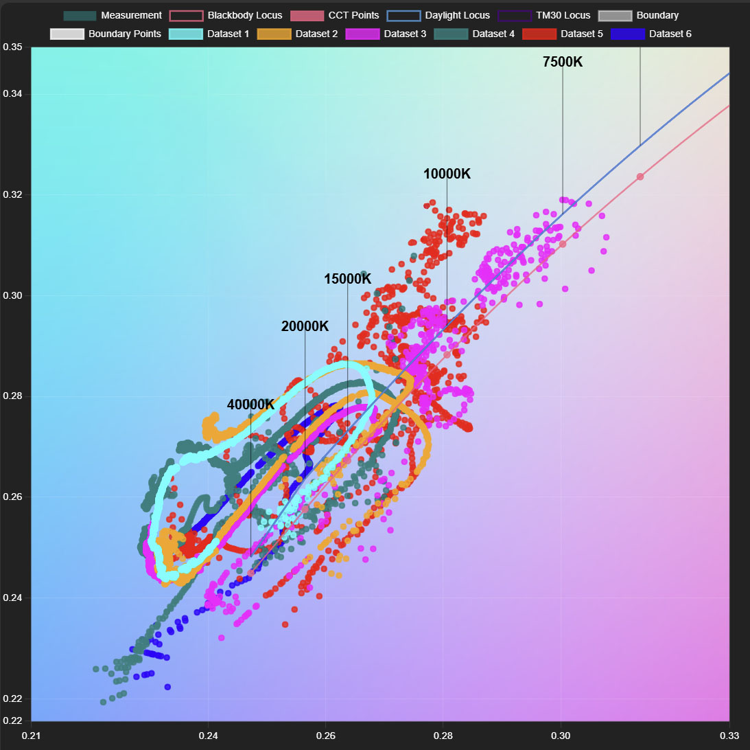
One issue with the current code is it doesn’t model clouds, haze, or smoke so the rendered sky can differ from what you see outside (numerous HN comments notice this). You can partially correct for this by using semi-realtime satellite imaging but hard to get super accurate which is what pushed us to develop our own sensor. There are various CCT sensors on the market already but they only measure directional+diffuse+reflected light which is typically ~7500k but the sky color goes up to 40,000k.
Here is a plot showing the color of the sky as it changes during the day from real sensor readings. Each one is 30s apart, so it change change quickly. https://www.innerscene.com/built_pages/cs_specsheet/cct/cct_...
A bit more info as well: https://www.innerscene.com/SpecHelp/CircadianSky/cct/cct.htm...
But it looked very cool earlier today when it matched!
what got me the most is opening chrome dev tools and seeing nothing there
Edit: I think its this link: https://sky.dlazaro.ca/ OP - put it in the HN post and first on your github repo! Good work.
This is really cool. I’ll probably see if I can make it my new tab background in Chromium.
https://www.icloud.com/shortcuts/c8ba254a0272453cbe39357b144...
Just make sure that your last (or only) iDevice Home Screen is set to type “image”.