California ill-prepared for the Big One, experts say https://phys.org/news/2016-07-california-ill-prepared-big-ex...
What Would Happen If Yellowstone's Supervolcano Erupted? https://www.livescience.com/20714-yellowstone-supervolcano-e...
America’s Crumbling Dams Are A Disaster Waiting To Happen http://www.huffingtonpost.com.au/entry/america-crumbling-dam...
Scientists say Seattle’s overdue earthquake could happen within 50 years http://mynorthwest.com/12944/scientists-say-seattles-overdue...
Ancient aliens are hibernating on Earth – and they are waiting to ATTACK - shock claims http://www.dailystar.co.uk/news/latest-news/618941/ancient-a...
There's nothing particularly interesting about old articles that appear to have predicted current events.
When it happens, someone will dig up the old article saying "are we ready for the floobledasch EVENT?!!!"
There is, if:
- they had valid grounds for making the prediction
- something could have been done to better prepare for the event
and
- the warnings were recklessly ignored.
I wonder if there have been studies comparing the costs? The hurricane is coming either way and there will be a need to cleanup.
Its the same in some software organizations, fixing things so they are right takes a lot of convincing vs. band-aids when the problem comes up.
Maybe if we keep hammering on about how people predicted this stuff the next prediction will get listened to a bit mroe.
A Houston floodsplainer, by Matt Corbett [caveat]
There will inevitably be extreme hottakes regarding flood planning and monday-morning quarterbacking of officials. This is for context. Some good links: [1] [2] [3] [4].
Houston is on a flat, mostly featureless plain, which is naturally drained by a number of Bayous. ("The Bayou City" refers to Houston, not New Orleans.) The bayous all run (and drain) from west to east, converging on either the ship channel or San Jacinto Bay.
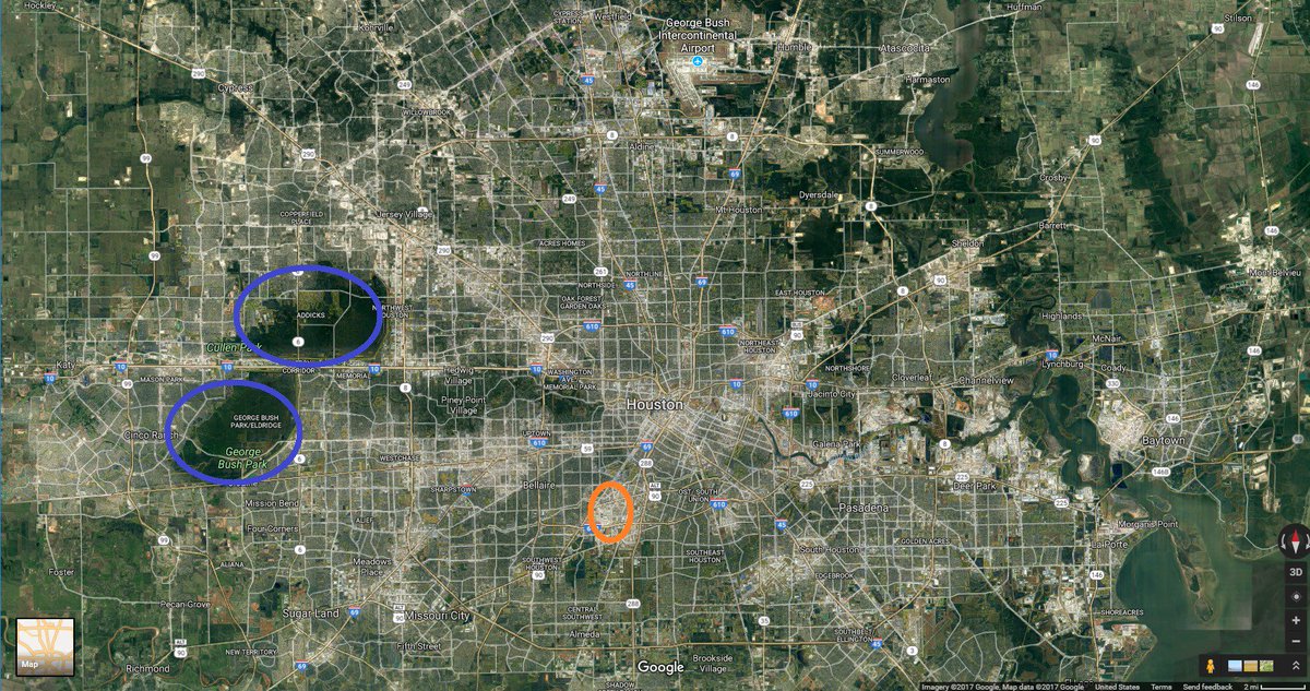
It also has varying development density. Here's a satellite photo which will roughly show that density: [Sat pic] (Note: I've highlighted 2 areas- Addicks & Barker reservoirs and the medical center, because I'll mention them later).
Houston has sandy soil and a high water table, and so has some limited ability to rely on absorption. (Related: No houses have basements and it would be nearly impossible to construct a subway.) Most of Houston is ~35-45'/12m above sea level.
Flooding risk is almost entirely from rain, not storm surges. Being on the Gulf Coast, Houston gets ~50" of rain a year. Gulf thunderstorms can get intense. Four-to-six-inches-in-8-hours storms happen about once a year. Flooding is essentially a rate problem: can you drain the water as fast as it comes? When the answer is 'no', water backs up along the drainage routes. [Sat pic with drainage routes] As a result, any person's flooding risk is mainly about proximity and elevation vs the nearest bayou.
The primary backups for the bayous handling too much water are the roads. In the 90s, Houston was getting large enough that relying on groundwater was starting to cause subsidence problems. The powers that be decided (wisely, mostly) to slowly convert all the roads into a giant rain collection network, so every time an asphalt road needed to be repaved, it got replaced with curb & gutter concrete with a big storm sewer underneath. This has been highly obnoxious to anyone living nearby when such a project was underway, but ultimately quite effective. It usually means that in flooding situations, roads briefly become rivers and then drain, saving houses from flood damage, but it's also a work in progress that has proceeded at the rate roads needed replacing, and it varies greatly by location.
The next backup for water are sections of freeways. Here, for example, is a section of I-69/US-59 (as [indicated on map].) Given the flood risk indication of the neighborhood immediately south, that sunken section serves a flood-relief purpose: [Flooded freeway]
Thus, flood control in Houston is and has been in a continual state of upgrade for 20 years. However, Houston has also been growing rapidly in that time, adding about 100-125 thousand people per year for 15 years. The result of this growth is that at any given time the flood control has been adequate, but only for the city T-5 years ago, not now. The currently least-adequate parts are usually around the geographic periphery and immediately downstream.
The key incidents forming city officials' decision making have been the experiences of Allison (2001), Rita (2005), Ike (2008) and the flooding events of the past 2 years (Memorial Day 2015 and Tax Day 2016).
Conceptually, Harvey is closest to Allison, which was a tropical storm that parked itself over Houston for 3 days and dumped 20" of rain [Tropical Storm Allison wiki]. A key quote:
> Despite massive flooding damage to entire neighborhoods there were no drowning deaths in flooded homes. In the area, there were twelve deaths from driving, six from walking, three from electrocution, and one in an elevator.
Rita (2005) was a huge storm, occurring ~1 month after Katrina. For a few days it was forecast to hit Houston directly, but it ultimately drifted eastwards and hit Port Arthur. Given the recent experience of Katrina, an evacuation was (very understandbly) ordered. The result, as described in an [Aman Batheja tweetstorm]:
> ...as the Houston Mayor debated evacuation, he had to weigh whether he was directing millions to sit in traffic as Harvey reached landfall, and also whether he might be creating thousands of new people who refuse to evacuate ever again.
Hurricane Ike (2008) is least directly relevant- in Houston it caused immense damage but comparatively little flooding and death except in the medical center, which lost power, and sustained lots of flood damage. The med center is an utterly critical component of Houston, and understandably a high priority for flood control. It employs ~150k people, conducts enormous amounts of cutting-edge research, and most importantly, at any given time has a large number of very sick, very immobile patients. It has therefore received (again, understandably) disproportionate flood-control attention in the past decade, but often at the expense of other areas in the city.
The other section I highlighted was the [Addicks & Barker reservoirs]. They are flood control reservoirs that date from the 1930s. They remain highly useful and functional, but given Houston's growth are now inadequate to the nearby area, which is where the worst flooding in Allison occurred. They are the focus of the Texas Tribune article linked above under [Good link 3], and I'd guess that's where the worst flooding will happen this time.
With all that background, now for the city's Harvey choices:
As of mid-last week, it was forecast that Harvey would produce "up to Allison" levels of rainfall. That was when any evacuation order would have had to be made. It's not possible to evacuate all of Houston inside of 48 hours. Too many people, not enough roads or time, and Houston would inherently be a lower priority than people closer to the coast. City & state leaders knew the rainfall would be very, very bad. But the experiences of Allison & Rita would lead to the belief that evacuation, especially on short notice, would lead to more death than hunkering down. Also, given that roads & freeways [flood] BY DESIGN, "stuck on the road" is the absolute worst, most dangerous place to be, thus an evacuation that stranded people mid-storm would be worst-case scenario. Embedded in that is a gamble that emergency services will be able to rescue people at the rate they become endangered.
That's a hard choice to make, and it will be examined for a long, long time [with] 20/20 hindsight. But decisions have to be judged by the best information available at the time, and at the time, it was justifiable. Perhaps on closer examination it will have been the wrong choice, but it is an entirely defensible one.
Many have noticed something of a gap a gap between Mayor Turner and Governor Abbott on this choice and hinted some sort of R/D partisan issue. More relevant is likely the Governor's handicap. Famously, within Texas, Governor Abbott is in a wheelchair, and is thus highly sensitive to the risks for people with limited mobility, who of course are/would be in the most danger if hunkering down proves the wrong choice. So the Governor likely has a different sense of risk than does the Mayor. This doesn't make it right or wrong, just a different value judgement. Judgement calls are as much about being able to live with a choice being wrong as they are about picking the outcome one thinks will be best. It's easy to see both sides of this one.
Addendum: Bill King, who narrowly lost to Turner for mayor, emphatically says Turner made the right call: [Times op-ed]. @MichaelBerrySho, former councilman, & frequent Turner critic also 100% agreed on the no-evacuation call: [Michael Berry tweetstorm].
> This is a complicated issue, & awful damage, but not ordering an evac was the correct decision. I ran for mayor AGAINST @SylvesterTurner. I've fought w/@EdEmmett. & I am SUPPORTING their good decisions during #Harvey.
[Good link 1] https://www.harriscountyfws.org/
[Good link 2] https://spacecityweather.com/
[Good link 3] https://www.texastribune.org/boomtown-floodtown/
[Good link 4] http://traffic.houstontranstar.org/cctv/transtar/
[Sat pic] https://pbs.twimg.com/media/DIRoKVNVYAAuzPc.jpg
[Sat pic with drainage routes] https://pbs.twimg.com/media/DIRokT7UwAEr53H.jpg
[Freeway indicated on map] https://pbs.twimg.com/media/DIRpK4-V4AAephw.jpg
[Flooded freeway] https://pbs.twimg.com/media/DIRpUBsVYAA2Gld.jpg
[Tropical Storm Allison wiki] https://en.wikipedia.org/wiki/Tropical_Storm_Allison
[Aman Batheja tweetstorm] https://twitter.com/amanbatheja/status/901867083608285184:
The debate of whether Houston should have issued a mandatory evacuation is more complicated than many probably realize. In 2005, the evacuation of Hurricane Rita was a bigger calamity than the hurricane itself: https://apps.texastribune.org/road-from-rita/taking-on-traff.... For days, major highways looked like parking lots. Dozens died before Rita even reached Texas.
> Of the 139 deaths that the state linked to Hurricane Rita, 73 occurred before Rita reached Texas. Twenty-three people died in a bus fire. Ten others died from hyperthermia due to heat exposure.
It was clear in hindsight that many evacuees would have been better off riding out the storm at home. Texas took measures to improve future evacuations but state officials admitted to me in 2015 that they weren't enough. 3 years later, the Texas evacuation ahead of Hurricane Ike went much better. But that's partly because of this:
> The Ike evacuation was also aided by tens of thousands of residents refusing orders to leave. For many, that decision was driven by the still-fresh memory of Rita.
Texas has grown like gangbusters since Rita. Growth in highway capacity hasn't come close to matching that.
> Between 2005 and 2014, the population of a 40-county area covering southeast Texas and the Gulf Coast grew by 20 percent, or more than 1.5 million people. Over the same period, highway lane miles in that region grew by just 5 percent, or 1,707 miles, according to state data.
Houston is the 4th largest city in the country with 2.3 million people. So as Houston Mayor debated evacuation, he had to weigh whether he was directing millions to sit in traffic as Harvey reached landfall, and also whether he might be creating thousands of new people who refuse to evacuate ever again. This is not a defense of Sylvester Turner's decision not to evacuate Houston. Just offering context of how complicated the decision was.
[Addicks & Barker reservoirs] http://www.swg.usace.army.mil/Missions/Dam-Safety-Program/
[Times op-ed] https://www.nytimes.com/2017/08/28/opinion/harvey-flooding-m...
[Michael Berry tweetstorm] https://twitter.com/MichaelBerrySho/status/90237864039826636... - not going to break this one out, lest I reproduce all of Twitter.
Energy industry could easily build such a "Ike Dike" but why should the city of Houston do such a thing? Bush lobbied strongly for it on behalf of the energy guys, but didn't get it. Now you see why.
Everywhere I go I see the things people have done to mitigate weather events: * commercial buildings with high water dams * freeway underpass pumping stations * new suburban neighborhoods and commercial centers with large water retention zones that become parks and playing fields in the 99% of the time they aren't underwater * infill housing in existing neighborhoods that is raised on piers to protect people without displacing water needlessly * regional sized water retention ponds for established neighborhoods that have become wetlands for migratory waterfowl and local wildlife.
Is there a lot left to be done? Sure. Could what is being done be done better? Sure, we learn all the time. I think learning is the reason why the current semi-organic approach is sound. The glass may be half empty or half full, but the fill rate is moving in a direction of increased storm resilience (which this week is toward empty for sure ).
It is also linked from the article, but embarrassingly took me a minute to find it.